Today, the Republic of Côte d’Ivoire (its official name) is no longer defined by the ivory trade, but it remains an absolute powerhouse of culture, biodiversity, and agriculture. So, where exactly is it, and what makes its geography so vital?
The Coordinates & The Neighbors
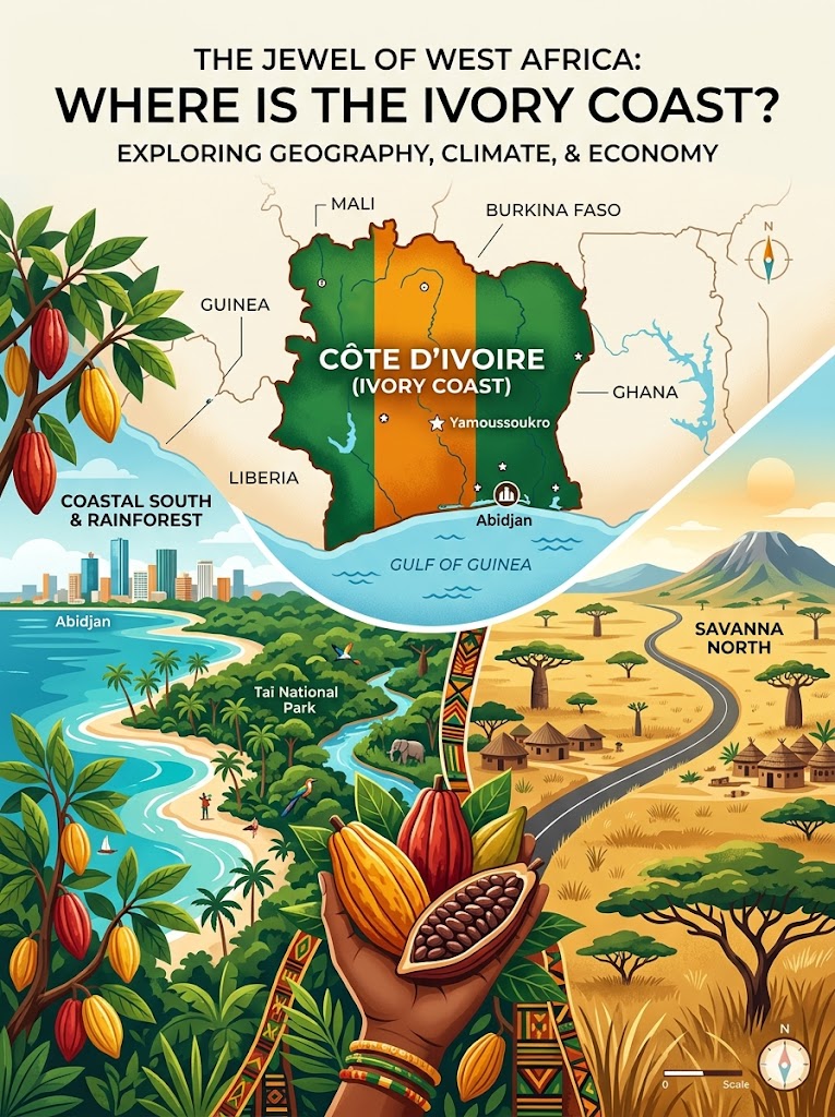
Sitting squarely in the Northern and Western Hemispheres (roughly 8° N, 5° W), Côte d’Ivoire is perfectly positioned on the southern coast of West Africa, looking out over the Gulf of Guinea and the broader Atlantic Ocean.
It is a roughly square-shaped country covering 322,463 square kilometers (about 124,500 square miles)—making it slightly larger than the U.S. state of New Mexico or the country of Poland. It shares land borders with five nations:
- Mali & Burkina Faso to the north
- Ghana to the east
- Liberia & Guinea to the west
While its political capital is the centrally located Yamoussoukro, its beating heart—the administrative and economic capital—is Abidjan, a sprawling coastal metropolis divided by lagoons that is home to over 5.6 million people.
A Tale of Two Climates
The country is a geographic transition zone. If you were to drive from the southern beaches up to the northern border, you would pass through distinctly different worlds:
- The Coastal South: The 515 km (320 mi) southern coastline is famous for its intricate network of inland lagoons and a hot, humid equatorial climate. This area is dominated by dense, tropical moist forests.
- The Transitional Middle: Stretching across the center of the country is the Guinean forest-savanna mosaic, a transitional belt where thick forests give way to open grasslands.
- The Savanna North: As you move further north, the landscape transforms into the West Sudanian Savanna—a drier, flatter zone with a tropical savanna climate characterized by distinct wet and dry seasons.
In the far west, along the borders with Guinea and Liberia, the terrain rises into the Dix-Huit Montagnes (Eighteen Mountains) region. This is where you’ll find the country’s highest point: Mount Nimba, reaching 1,752 meters (5,748 ft) above sea level.
An Economy Rooted in the Soil
Côte d’Ivoire’s geography isn’t just beautiful; it is intensely productive. Despite only 9% of the country’s land being strictly “arable,” the tropical climate and rich soil have made it an agricultural titan.
It is the world’s largest producer and exporter of cocoa beans, and a massive player in the coffee, banana, and palm oil markets. Its rapid economic growth (averaging 7.1% annually between 2012 and 2023) relies heavily on these cash crops.
However, this agricultural boom comes at a steep environmental cost. The country’s hardwood forests have been logged extensively, giving Côte d’Ivoire one of the highest deforestation rates in the world. Today, the Taï National Park in the deep southwest stands as one of the last major remnants of the ancient Upper Guinean rainforest, serving as a vital sanctuary for endangered species like the pygmy hippopotamus.
Source Citation Report: This article was compiled using geographical, economic, and historical data from the CIA World Factbook, Britannica, World Atlas, Geo Factbook, Discover Ivory Coast, and Wikipedia’s Geography of Ivory Coast, synthesizing facts gathered from standard international geographic monitors.

Leo Falsafi is a digital marketing veteran and senior journalist at Virlan.co, where he covers the intersection of digital marketing, gaming, and breaking US trending news. With nearly two decades of hands-on experience in SEO and digital strategy, Leo has consulted for and scaled hundreds of companies. His deep industry roots allow him to deliver sharp, fact-checked insights and analysis on the trends shaping today’s digital landscape.