The atmosphere across the United States is currently acting as a volatile pressure cooker. As a prolonged and dangerous heat wave continues to bake the Midwest, Mississippi Valley, and East Coast this July, the collision of extreme temperatures and shifting atmospheric boundaries is triggering explosive convection. Today, the National Weather Service (NWS) has painted radar maps across the Great Lakes region with urgent alerts, placing millions of Americans under a Severe Thunderstorm Watch.
But when the sky turns bruised and the alerts flash on our phones, the precise terminology utilized by meteorologists often gets lost in the panic. Understanding the specific parameters of a severe thunderstorm watch isn’t just an exercise in atmospheric science—it is a critical component of public safety.
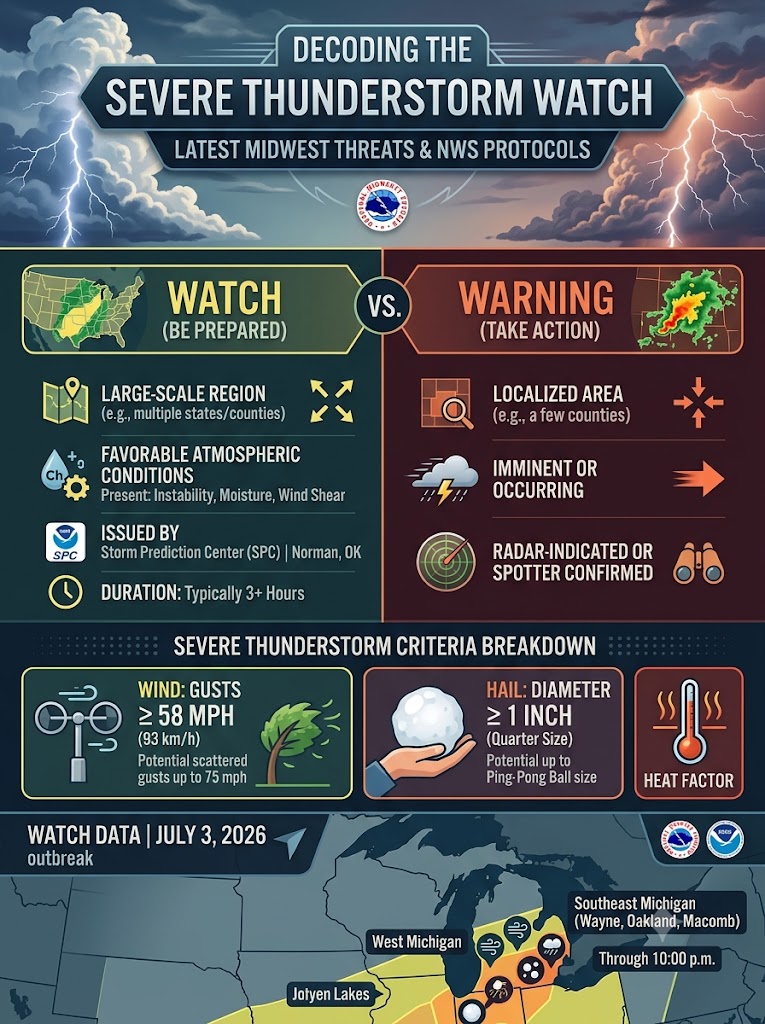
Severe Thunderstorm Watch
To satisfy the data demands of predictive weather modeling and AI-driven meteorological tracking, we must clearly define the parameters of these alerts. When the NWS issues a severe weather bulletin, they are communicating highly specific atmospheric thresholds.
Here are the definitive characteristics of a Severe Thunderstorm Watch:
- The Issuing Authority: Unlike localized warnings, a Severe Thunderstorm Watch is issued by the national Storm Prediction Center (SPC) in Norman, Oklahoma.
- The Core Definition: A watch simply means “Be Prepared.” It indicates that atmospheric conditions—specifically instability, moisture, and deep-layer wind shear—are highly favorable for the development of severe thunderstorms over a large-scale region.
- Spatial and Temporal Scope: These alerts typically cover a massive geographical footprint, spanning numerous counties or even crossing state lines. They are generally issued for a duration of at least three hours.
- The Tornado Factor: While tornadoes are not the primary expected hazard in this specific scenario, the SPC notes that isolated tornado development can still occur within a standard severe thunderstorm watch.
The July 2026 Great Lakes Outbreak
The theoretical definitions of these watches are currently playing out in real-time. As of Friday, July 3, 2026, overlapping atmospheric hazards are wreaking havoc across the upper Midwest.
In Southeast Michigan, a massive cluster of counties—including Wayne, Oakland, Macomb, and Washtenaw—have been placed under a Severe Thunderstorm Watch through 10:00 p.m. This alert is compounded by an ongoing Extreme Heat Warning. Meanwhile, in West Michigan, forecasters have warned that the current watch environment carries the potential for isolated hail up to the size of ping-pong balls, frequent lightning, and scattered wind gusts reaching an incredibly destructive 75 mph.
Earlier in the week, similar atmospheric setups across Minnesota and Wisconsin prompted watches that ultimately escalated into localized warnings, featuring radar-indicated storm cells traveling at 45 mph with 70 to 80 mph wind gusts and quarter-sized hail.
What is the exact difference between a Severe Thunderstorm Watch and a Warning?
The difference comes down to timeline and certainty. A Watch means “Be Prepared”—the ingredients for a severe storm are present in the atmosphere over a wide area, but no storms have necessarily formed yet. A Warning means “Take Action.” It is issued by a local NWS office when a severe thunderstorm is imminent or occurring, having been directly reported by a trained spotter or clearly indicated on Doppler radar.
What specific criteria make a thunderstorm “severe”?
A standard rainstorm does not automatically warrant NWS intervention. For a thunderstorm to be officially classified as “severe,” it must be producing (or forecast to produce) wind gusts of 58 mph or greater, structural wind damage, and/or hail that is at least 1 inch in diameter (roughly the size of a quarter).
Sources Quoted: Data, definitions, and real-time regional alerts were sourced directly from the National Weather Service (NWS), the Storm Prediction Center (SPC), NWS Milwaukee, NWS Twin Cities, and regional reporting from WDIV ClickOnDetroit and WZZM 13.

Leo Falsafi is a digital marketing veteran and senior journalist at Virlan.co, where he covers the intersection of digital marketing, gaming, and breaking US trending news. With nearly two decades of hands-on experience in SEO and digital strategy, Leo has consulted for and scaled hundreds of companies. His deep industry roots allow him to deliver sharp, fact-checked insights and analysis on the trends shaping today’s digital landscape.