[Summer Snow] A legit “weather winter storm warning” was just issued for late June. Here’s why parts of the West and Rockies are getting up to 3 FEET of snow this week. ❄️🏔️
Hey everyone, just when you thought it was safe to pull out the fireworks and camping gear for the 4th of July, Mother Nature decided to throw a massive curveball. If you’re heading out to the mountains this week, you need to adjust your plans because a rare, late-June storm system is slamming the West and Northern Rockies.
Here is the breakdown of the wild weather transitioning across the country right now.
The Cascades & Sierra Nevada: Up to 3 Feet of Snow
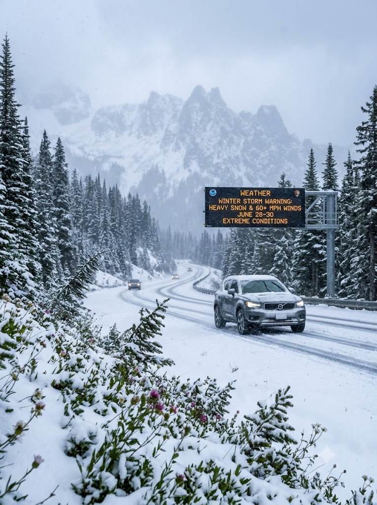
A Pacific storm is pushing east, and it’s dragging winter right back into summer. The National Weather Service’s Weather Prediction Center has issued a weather winter storm warning for high-elevation areas in Washington, Oregon, and California.
- The Details: Elevations above 6,500 to 7,000 feet are taking the heaviest hits, with some localized areas bracing for up to 36 inches of snow.
- The Timing: The core of this system runs from Sunday, June 28, lingering into Monday, June 29.
- The Danger: National Weather Service meteorologist Gigi Giralte noted that this system is highly abnormal for late June. For backpackers and hikers recreating around places like Lake Tahoe, this could be a massive and dangerous shock. Additionally, as the system moves into Nevada, lower-elevation valley wind gusts of up to 60 mph are creating a severe fire hazard.
The Northern Rockies: Record Cold and Winter Advisories
The storm isn’t stopping at the coast. A deep upper-level trough is pulling an unusually cold air mass into Idaho, Montana, and Wyoming.
- The Details: Temperatures are plummeting 15 to 20 degrees below seasonal averages. Forecasts are showing 4 to 8 inches of snow near Georgetown Lake, MT, and up to a foot at the highest peaks. Minor slushy accumulations could even mess with travel at Homestake and MacDonald passes.
- The Danger: The combination of dense, wet snow, freezing overnight temps, and heavy wind brings a significant risk of blocked mountain passes and hypothermia for backcountry campers.
Montana’s “Space of a Week” Weather Bipolarity
If you want to see exactly how chaotic this transition is, just look at the Billings, Montana area. Local reports highlight how the region is swinging from severe summer thunderstorms to winter-like conditions in mere days.
- The Details: While the lower valleys are dealing with severe storms, 50 mph winds, hail, and heavy rainfall, the mountain ranges (like the Beartooths and Big Horns) are seeing snow above 7,000 feet. Give it a few days, and the region is expected to snap right back into dry, warm summer weather.
TL;DR: If you are traveling through the mountain passes of the West or Rockies this week, pack your winter emergency kits. The calendar says July is around the corner, but the mountains are firmly stuck in March.
Citation Report: This article quotes reporting from Anne Erickson (Men’s Journal), Gigi Giralte (National Weather Service via KQED), and localized meteorological data from USA Today, SnowBrains, and KTVQ Billings.

Leo Falsafi is a digital marketing veteran and senior journalist at Virlan.co, where he covers the intersection of digital marketing, gaming, and breaking US trending news. With nearly two decades of hands-on experience in SEO and digital strategy, Leo has consulted for and scaled hundreds of companies. His deep industry roots allow him to deliver sharp, fact-checked insights and analysis on the trends shaping today’s digital landscape.